Three new maps chart the way forward
Tuesday, July 28, 2020 by Tai Moses
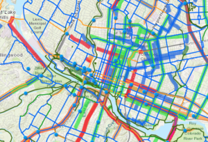
City departments have been busy making maps and have three new maps to share with the public. The newly updated Austin Bike Map helps cyclists find the best route for their next two-wheeled excursion. Recent additions to the map include the Shoal Creek, Wickersham Lane and Zach Scott Street bikeways. The map includes information about the comfort level of different routes and also when helpful sidewalks are present. The bike map may be viewed online, and hard copies can be found at many local bike shops. Also fresh off the presses is the Austin Urban Trails Interactive Web Map, which depicts existing paved urban trails throughout the city as well as proposed trails from the Public Works Department’s Urban Trails Program. The new web map is based on the 2014 Urban Trails Plan, “which identified 407 miles of urban trails to be built throughout the city. In 2019, the Austin Strategic Mobility Plan identified urban trails as an integral part of the transportation network needed to achieve the goal of a 50/50 mode share by 2039.” That goal is for half of Austinites to be using alternative transportation methods instead of driving alone in their cars. The two transportation maps join Austin Public Health’s interactive Covid-19 testing locations map, released earlier this month, which shows APH-operated sites along with other testing options for those who have insurance or a primary care provider. The map includes testing site operating hours, how to make an appointment, the type of test performed, and which lab the company uses for processing the tests.
Join Your Friends and Neighbors
We're a nonprofit news organization, and we put our service to you above all else. That will never change. But public-service journalism requires community support from readers like you. Will you join your friends and neighbors to support our work and mission?