Newsletter Signup
The Austin Monitor thanks its sponsors. Become one.
Most Popular Stories
- City leaders evaluate surprising ideas for water conservation
- Audit: Economic official granted arts, music funding against city code
- Parks Board recommends vendor for Zilker Café, while voicing concerns about lack of local presence
- Dozens of city music grants stalled over missing final reports
- Council reaffirms its commitment to making Austin a more age-friendly city
-
Discover News By District
Popular Whispers
Sorry. No data so far.

Photo by Gabriel C. Pérez/KUT
Hotter, stormier, droughtier: What to look for as meteorologists update ‘normal’ weather for Austin
Tuesday, April 27, 2021 by Mose Buchele, KUT
When you hear a weatherperson mention Austin’s average high temperature or rainfall next month, the numbers will be different. The National Oceanic and Atmospheric Administration is updating what it considers “normal” weather throughout the country.
And NOAA says climate change is self-evident in the new data.
Government statistics on normal weather – including high and low temperatures and rainfall – are typically taken from a 30-year running average. That information is updated every 10 years.
For the last decade, much of what we’ve been told is normal in Austin has been based off weather data from 1981 through 2010. Next month’s update will jettison the information from the ’80s and include the most recent decade.
NOAA has not released details yet. But Victor Murphy, Southern region climate service program manager with the National Weather Service, said we can expect hotter average temps. In Austin, he said, expect an increase in average yearly rainfall, but a decrease in the number of rainy days.
It’s Getting Hot in Here
Murphy didn’t get into specifics, pending NOAA’s final data release. But he said we can expect average low and high temperatures to increase by about 1/2 to 1 full degree Fahrenheit “in Austin and pretty much statewide in Texas.”
The expected change in average annual rainfall in Austin was even more striking.
“It looks like it actually increased by about 2 inches from about 34.2 inches to 36.2,” Murphy said. “But the number of days with measurable precipitation actually decreased by about maybe one day less per year.”
That increase in average rainfall, but decrease in number of wet days, shows how Austin has experienced more heavy storms in the recent past, but also more dry days. It’s a trend toward weather extremes like droughts and floods that climate scientists have been warning about for years.
“It ties right in with what we’re hearing about climate change,” Murphy said.
Is Texas Ready?
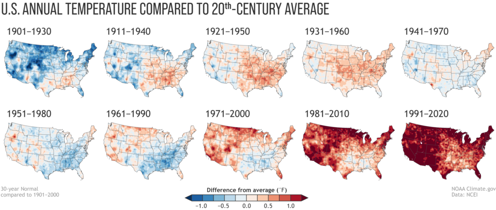
Using more recent information will help people better understand what to expect weather-wise in the near future. But some may worry that the 30-year rolling average leaves too much climate history out, obscuring the severity of climate change over the last century.
A NOAA article on the update pushes back against that idea. In it, Rebecca Lindsey argues comparing the 30-year averages can be a powerful took to demonstrate just how much hotter much of the U.S. has become since record-keeping began.
Murphy said the new information will do more than simply put daily weather in perspective.
“Numbers like this are really pretty huge as far as construction, engineering and things like that,” he said, suggesting the new data could help guide efforts to improve flood control and the Texas electrical grid.
“Ten years from now, will we have another half degree to 1 degree increase in temperatures going forward?” he said. “I think it stands pretty clear … that will be the case and we’ll have even more demand on electricity, on air conditioning, on infrastructure.”
This story was produced as part of the Austin Monitor’s reporting partnership with KUT.
The Austin Monitor’s work is made possible by donations from the community. Though our reporting covers donors from time to time, we are careful to keep business and editorial efforts separate while maintaining transparency. A complete list of donors is available here, and our code of ethics is explained here.
You're a community leader
And we’re honored you look to us for serious, in-depth news. You know a strong community needs local and dedicated watchdog reporting. We’re here for you and that won’t change. Now will you take the powerful next step and support our nonprofit news organization?


