Newsletter Signup
The Austin Monitor thanks its sponsors. Become one.
Most Popular Stories
- Firefighters to seek firing of Chief Baker
- Office slowdown sparks new downtown housing ambitions
- City leaders evaluate surprising ideas for water conservation
- Downtown Historic Resource Survey eyes seven new districts eligible for designation
- With cap of $687M, bond task force to weigh $4.4B in city needs
-
Discover News By District
Popular Whispers
Sorry. No data so far.

Safe Routes to School infrastructure reports posted for each Council district
Monday, May 4, 2020 by Ryan Thornton
Austin Public Works has released its final Safe Routes to School reports and project recommendations totaling over $825 million in improvements to make it safe and easy for children and families to walk or bicycle to and from school.
Austin’s Safe Routes to School program seeks to encourage more students to walk and bike to school through education, training and active transportation infrastructure. Approximately 17 percent of students in Austin have walked or taken a bicycle or scooter to school in recent years.
“It is important for children and their families to learn safe bicycling and walking practices together,” the citywide summary states. “Communities with higher active transportation rates tend to have lower crash rates for people bicycling and walking. As more members of a community become aware of people bicycling and walking on roadways, communities as a whole become safer.”
The reports posted Wednesday include conceptual improvements for streets, sidewalks, intersections, and trails serving 137 elementary and middle schools across the city.
Projects ranked either “high” or “very high” in overall benefit total over 300 miles of bike lanes, 66 miles of traffic calming for neighborhood bikeways, 166 miles of bidirectional sidepaths, and 432 miles of new or improved sidewalks.
As a next step, the city will prioritize projects for funding based on their overall benefit score as well as an estimated cost-benefit analysis. Selected projects will be paid for through the 2016 mobility bond, which included $27.5 million for the program, divided evenly among the 10 City Council districts.
The city is also looking for additional funding sources. A relatively modest amount of money has already been committed to the program with money left over from the Capital Metropolitan Transportation Authority’s quarter-cent fund.
In the recent update to the fund’s project list, Mayor Pro Tem Delia Garza committed to use some of District 2’s quarter-cent funds to share the cost for two pedestrian hybrid beacons along school routes; Council Member Alison Alter allocated $665,055 to the program in District 10; Council Member Jimmy Flannigan included $200,000 for his district; Council members Pio Renteria and Greg Casar both dedicated any unused quarter-cent funds from canceled or finished projects to the program; and Council Member Leslie Pool added $331,000 for sidewalks that she said will effectively serve as a Safe Routes to School project for students of Highland Park Elementary School.
After two years of planning, walk audits, public meetings, and online surveys, the Safe Routes to School program has identified 4,654 projects to help students and families get to and from school. The projects include:
- 378 traffic control/intersection reconfiguration projects for a total of $47.5 million
- 1,567 ramp/curb extension/crosswalk projects for a total of $42 million
- 8 over/underpass projects for a total of $15.6 million
- 214 off-street trail projects for a total of $90 million
- 253 bike lane projects for a total of $90 million
- 134 sidepath projects for a total of $259.5 million
- 116 neighborhood bikeway/traffic calming projects for a total of $6 million
- 1,714 sidewalk projects for a total of $257 million
Many projects are listed as “very high” priority but low in terms of overall cost-benefit. In District 1, for instance, an overpass or underpass connecting Andrews Elementary School in Northeast Austin to the neighborhood north of U.S. Highway 290 East is ranked “very high” in benefit because more than half of the school’s students live north of the highway and have no access to the school. However, the project is ranked “very low” for cost-benefit.
In the past two years, the program team made contact with 360 people online and in person and received over 750 comments. Over 89 percent of all participants said they walk for some trips and 51 percent said they would like to use a bicycle more often.
“Our children bike or walk to school along a street where there is some sidewalk, but there are gaps,” said one parent. “It would be much safer if the kids could walk or bike on a contiguous sidewalk.”
Safe Routes has completed 50 projects so far and is making progress on another 25. The city plans to update the infrastructure reports every five years.
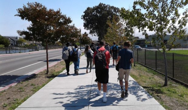
Photo made available through a Creative Commons license.
The Austin Monitor’s work is made possible by donations from the community. Though our reporting covers donors from time to time, we are careful to keep business and editorial efforts separate while maintaining transparency. A complete list of donors is available here, and our code of ethics is explained here.
You're a community leader
And we’re honored you look to us for serious, in-depth news. You know a strong community needs local and dedicated watchdog reporting. We’re here for you and that won’t change. Now will you take the powerful next step and support our nonprofit news organization?


