Critical water quality zone crossing approved for the second time
Wednesday, July 25, 2018 by
Jessi Devenyns Sometimes for development projects, it’s the second time that’s the charm.
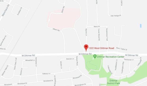
Over a decade ago, developers of a 42-acre tract of land at 1322 W. Dittmar Road received a variance to construct a private drive across a critical water quality zone to develop the northern portion of the property. However, due to the project never breaking ground, the variance that they had been granted expired and returned the plan back to square one.
In a bid to revive the project, Dave Anderson of the Drenner Group and representative for the applicant came to the July 18 meeting of the Environmental Commission to receive re-approval for the variance. His request was unanimously approved for recommendation to Council by commissioners.
“We’re requesting the same variance we requested in 2007 and was approved by this body,” Anderson told the commission. Although he was requesting the same variance, it is now subject to current code, which includes the Heritage Tree Ordinance and greater setbacks in critical water quality zones.
With these considerations in mind, Chair Linda Guerrero asked if “this is a better project now than it was in 2007.”
Anderson noted that beyond the fact that development now has to abide by more restrictive environmental regulations, “we feel like it’s a pretty solid environmental design.” The current plan has nearly 10 acres of dedicated parkland; code requires 6 acres to be set aside. Similarly, “we’re somewhere around 38 percent impervious cover … and the allowable is 55 percent,” said Anderson.
The project also has a plan to provide three access points to its parkland for the neural rehab facility that shares a boundary with this tract of land to give patients access to the outdoors.
Even the plan to build a crossing across a “major critical water quality zone” did not raise too much discussion. Environmental Program Coordinator Mike McDougal explained that the only entrance to the property is from Dittmar Road, which means that in order to access the entire property there will need to be a crossing at the critical water quality zone.
According to him, without the critical water quality zone crossing, “only the area south of the critical water quality zone is accessible and land-developable, and this represents about 5 of the total 42 acres of the property.” He said that he worked with the applicant to help them design their plans to avoid the rim rock critical environmental feature as well as shift the bridge to preserve many of the trees on the property.
Anderson outlined how the project is also taking into account the impending Atlas 14 flood plain changes. “So as you think about Atlas 14, we have looked at this and do not expect it to overtop the bridge.” To clarify the safety of the bridge, he also noted that the piers will be driven into the earth below the erosion hazard zone “so the bridge will remain safe.”
With assurances of safety for both the environment and for people, once again, the Environmental Commission saw fit to recommend the approval of this variance and voted unanimously to do so.
The Austin Monitor’s work is made possible by donations from the community. Though our reporting covers donors from time to time, we are careful to keep business and editorial efforts separate while maintaining transparency. A complete list of donors is available here, and our code of ethics is explained here.
You're a community leader
And we’re honored you look to us for serious, in-depth news. You know a strong community needs local and dedicated watchdog reporting. We’re here for you and that won’t change. Now will you take the powerful next step and support our nonprofit news organization?