New flood warning website should give Central Texans a closer look at risks
Friday, March 2, 2018 by Mose Buchele, KUT
A website that warns Central Texans about road flooding is getting an overhaul this month. The designers of the new site say the changes should give visitors more detail about flooding near them.
ATXfloods.com is basically a map that shows which low-water crossings are underwater. On a sunny day, it should be full of green circles to say the crossings are OK. During heavy rains, those green circles turn to red.
The site was launched by the city of Austin in 2012 and has been visited 9 million times, a number that makes sense when you consider how many floods the area has had since then.
Matt Porcher, a systems administrator with the city’s Flood Early Warning System team, says the website has been due for an upgrade for awhile.
One reason? The old site had maxed out on the amount of data it could share. That meant crossings in parts of Central Texas couldn’t be added.
“I think kind of the neatest thing (about the new website) is that we’ll be able to add more jurisdictions in the Central Texas area,” Porcher said.
At some point this year, people will be able to sign up for text and email notifications about specific crossings. Plus, you’ll be able to take a look at images from more cameras set up at many more spots.
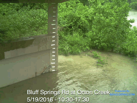
The idea is to provide a view of “what’s happening on the ground right now,” said Sean Richardson with Beholder Technology, the tech company hired by the city to work on the site.
Richardson said the cameras should help reduce the need to send first responders out to check on crossings and help people understand the magnitude of the danger floods pose.
One good example of the power of flood images? During a recent storm, Richardson said, a camera took pictures as the water rose to submerge it, then suddenly began taking images of the sky and trees as it was swept away.
“If you show an image you can be like, ‘Wow, that water is really rising!’” Richardson said. “It’s hard to understand that if you haven’t seen it firsthand.”
Other features of the new website include: different shapes to indicate whether a crossing’s status is closed, open or unknown, to help people who are colorblind, and a new symbol to tell users if a crossing’s status has not been updated for several days.
In the future, Richardson hopes to create a map like ATXfloods.com to cover the entire state of Texas and integrate it with navigation platforms like Waze and Google Maps.
“How powerful would it be if not only did your navigation software tell you, ‘Hey, there’s congestion,’ but it goes, ‘Hey, actually, this water crossing is closed’?”
The new site should launch sometime later in March, with some of the new features rolling out in the following months.
This story was produced as part of the Austin Monitor’s reporting partnership with KUT. GIF courtesy of Sean Richardson.
The Austin Monitor’s work is made possible by donations from the community. Though our reporting covers donors from time to time, we are careful to keep business and editorial efforts separate while maintaining transparency. A complete list of donors is available here, and our code of ethics is explained here.

You're a community leader
And we’re honored you look to us for serious, in-depth news. You know a strong community needs local and dedicated watchdog reporting. We’re here for you and that won’t change. Now will you take the powerful next step and support our nonprofit news organization?