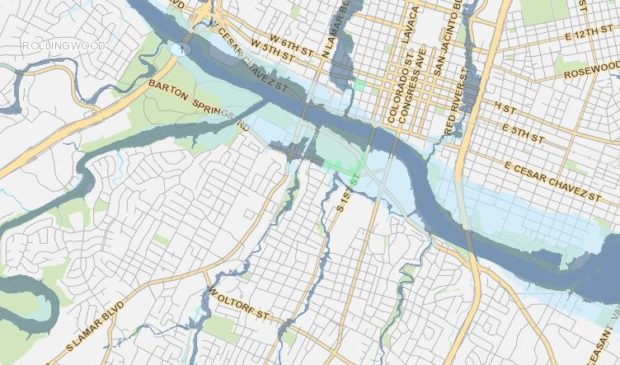
Austin’s 100-year flood plain looks more like today’s 500-year flood plain
Thursday, March 22, 2018 by
Jessi Devenyns In Austin, flooding has been a concern for decades, but in the last several years, the urgency with which the city is conducting the conversation has escalated. In the last four years alone, Austin has experienced four federally declared flooding disasters, and the rain doesn’t seem to be letting up according to a new study done by the National Weather Service.
Called Atlas 14, this study shows that there has been a significant increase in precipitation across Central Texas and down to Houston. This Precipitation-Frequency Atlas comprises decades of studies done by the Hydrometeorological Design Studies Center within the Office of Water Prediction of the National Oceanic and Atmospheric Administration’s National Weather Service and is currently in peer review with an official release set for this summer.
Following the release of the study for peer review, Kevin Shunk, the Engineering Division manager of the Watershed Protection Department, and Matt Hollon, the manager of the Watershed Protection Department’s Planning Division, sat down with the Austin Monitor to discuss the implications these new flood plain maps would have on Austin.
Although there is no official green light to begin studying and implementing the data that this atlas reveals, “We are aware of the major changes that it proposes and we’re considering how to incorporate those changes into our current criteria,” Shunk told the Monitor.
These changes include a remarkable increase in the anticipated rainfall and Austin’s flood plain size. While this may affect individual properties that suddenly find themselves in a flood plain, the biggest implications will come from the requirements in flood mitigation and drainage that developers will face.
Shunk explained the department’s pre-emptive attention to the upcoming changes, saying, “We’re working on it now before the data is released, so that when the data is released we have a plan in mind and we can address some of the questions … and hit the ground running.”
Hollon told the Monitor that the department is even going as far as talking to current applicants for projects about the impending changes.
Nevertheless, not everyone is aware of what is coming down the pipeline, so to speak.
According to Hollon, all of the storm events will “shift up a notch.” That means that what today has a 1 percent chance of being flooded, will, with the release of the new precipitation atlas, have a 4 percent chance of being flooded. Despite the fact that according to the department’s preliminary estimates there will be approximately 70 percent more structures in the flood plain, Hollon said not to worry. “The flood plains are only about 10 or 12 percent of all land area, so most people don’t actually have to worry about a flood plain with their properties,” he said.
Shunk told the Monitor that he doesn’t expect the higher rainfall intensities that are highlighted by this study to increase the risk of already flood-prone areas of the city. “It just means what is the highest risk now, has more risk,” he said.
Currently, the flood plain maps that are used to identify risk-prone areas and guide development are from 1998. The data used to draw these maps were collected in the middle of the previous century. In the face of the upcoming sweeping changes associated with CodeNEXT, updating the flood plains to compare accurately against new regulations is an important step.
However, Shunk explained that it is not imperative that Atlas 14 is available to developers prior to the passage of CodeNEXT. “There’s still flood risk, and CodeNEXT is trying to propose how we can address that flood risk no matter what that flood risk is,” he said.
Although the study is still in peer review, Shunk noted that he does not expect the data to change significantly. Hollon agreed with his assessment and said, “Atlas 14 is based on data that already happened. We’re not talking about the future here, we’re talking about where we already are.”
Yet, Hollon said that because this new atlas is based on data from the past, what the future holds is anyone’s guess. Both Shunk and Hollon admitted that the weather patterns in the last several years have been erratic. This unpredictability makes it difficult to plan and codify flood mitigation techniques. “That’s the nerve-wracking part about this,” explained Hollon. “These data keep changing.”
The Austin Monitor’s work is made possible by donations from the community. Though our reporting covers donors from time to time, we are careful to keep business and editorial efforts separate while maintaining transparency. A complete list of donors is available here, and our code of ethics is explained here.
You're a community leader
And we’re honored you look to us for serious, in-depth news. You know a strong community needs local and dedicated watchdog reporting. We’re here for you and that won’t change. Now will you take the powerful next step and support our nonprofit news organization?


