
The most ambitious of Austin’s light-rail plans would burrow four miles of tunnel beneath downtown and South Austin to connect six subterranean stations and create the city’s first subway system.
The subway would make up the centralized portion of the light-rail network. The other 20 stations would be above ground.
Project Connect’s growing price tag – the cost of the transit tunnel alone has doubled to more than $4 billion – could force transit planners to scale back their underground aspirations.
But the vision presented by the Austin Transit Partnership and its consultants previews a future where Austin would join the ranks of American cities with their own iconic subways like New York, Chicago, Boston, Philadelphia and San Francisco.
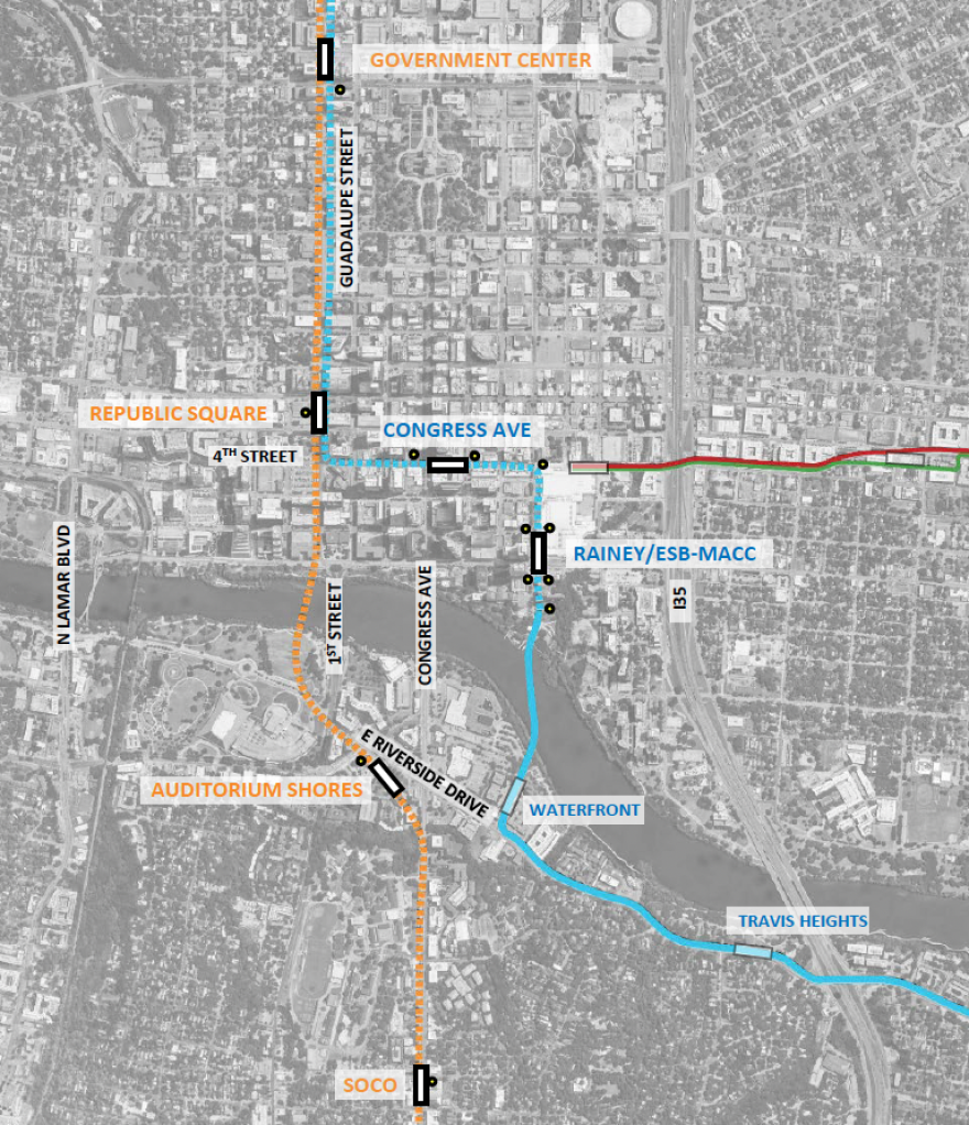
Four subway stations would be on the Orange Line, whose first phase includes 14 stations between Stassney Lane and North Lamar Transit Center. Two subway stations would be on the Blue Line, an 8.2-mile route from Austin-Bergstrom International Airport to Republic Square Park.
Each station would have highly visible entryways, minimal blind spots and natural light where possible. Stations could have amenities like stores, public restrooms, bike pumps and USB charging stations.
All stations would have escalators and elevators.
Under the most elaborate proposal, a pedestrian concourse would allow someone to walk from the Ann and Roy Butler Hike and Bike Trail beneath Trinity Street to Fourth Street and then turn west and continue down Fourth to Republic Square Park.

ATP is seeking feedback on cost-saving ideas including limiting the size of the underground concourse.
Capitol West/Government Center Station

The subway station closest to the Texas Capitol Complex, one of the city’s major employment centers, would be on Guadalupe Street between 15th and 17th streets.
The most prominent entrance would be on 15th Street. ATP would have to seize some private property from the DoubleTree Suites to create space for a plaza.
A sidewalk entrance – the name for an entrance that fits within the footprint of the existing sidewalk – is planned for 17th Street.
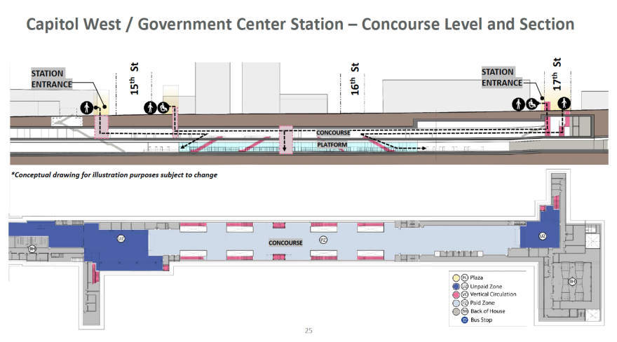
People walking into the station from the street would land in the dark blue area indicated with a UZ, which stands for “unpaid zone.” After paying, riders could walk into the main concourse area and take the escalator or elevator to the platform below.
The gray areas labeled BH contain critical “back of house” infrastructure like lighting, air conditioning and ventilation – crucial for maintaining safe air quality underground. Those areas would be closed to the public.
Republic Square Station

This busy transit station where the Orange and Blue lines connect is named after Republic Square but won’t actually touch the state-owned park at all. Legislation that would have allowed for a transit station under the park failed to pass the Texas Legislature last year.
So Republic Square Station will be just north of Republic Square Park with a prominent entry plaza on Guadalupe Street between Fifth and Sixth streets. Two elevators and two escalators would take people down to the concourse level.
A secondary sidewalk entrance at Fourth Street would connect to an underground pedestrian concourse taking people to the Republic Square Station or letting them walk underground to the Congress Avenue station.

The Republic Square Station would have three levels, allowing the back-of-house infrastructure to be tucked out of the way of the long continuous concourse.
The largest of the subway stations would be 100 feet beneath the ground at its deepest points.
Auditorium Shores Station

South of Lady Bird Lake, the Auditorium Shores Station would be located near the intersection of Riverside Drive and Barton Springs Road.
The area is in a floodplain with many large underground utilities making it one of the most challenging stations to engineer.
Auditorium Shores and Government Center are planned as two-level stations. They’d be about 50 to 60 feet underground at their deepest points.
The underground pedestrian tunnel connecting the South First Street entrance to the station would likely cost more than $100 million and could be removed from the project to cut costs.

ATP planners said they want public feedback on whether it’s worth $100 million for passengers to have easier access to the Long Center and Auditorium Shores.
SoCo Station

The underground station on South Congress Avenue would sit between Monroe and Elizabeth streets.

The Orange Line station had originally been imagined as above-ground farther north on South Congress. But ATP says the state’s Capitol View Corridor law – which protects views of the Capitol Dome – restricts any on-street construction north of Live Oak Street.
Putting the SoCo Station underground allows for it to be in a more centralized location along the busy commercial street and requires less seizure of private property. But extending the tunnel to Live Oak Street increases the estimated cost by more than $1 billion.
Congress Avenue Station

This Blue Line station would be on Fourth Street between Congress Avenue and Brazos Street with entrances on either side. The station would be accessible by an underground pedestrian concourse that could connect as far as the Hike and Bike Trail at Trinity Street.
The Congress Avenue Station would have four to five elevators and a similar number of escalators to accommodate a high volume of passengers in the population-dense area.

Rainey/ESB-MACC Station

The station named after Rainey Street and the Emma S. Barrientos Mexican American Cultural Center (ESB-MACC) would have multiple entrances both north and south of Cesar Chavez Street.
A pedestrian concourse ramp called the Lady Bird Lake Entrance would provide close access to the ESB-MACC, the Rainey Street District and the Butler Hike and Bike Trail.

The Lady Bird Lake entrance would gently slope upward toward ground level into a landscaped area. The train would emerge above-ground and cross a bridge. ATP is still deciding whether to permit Capital Metro buses on the bridge. Pedestrians and cyclists will be allowed.

Brush Square Entrance

This is not a station, but the Brush Square Entrance would provide access to the Congress Avenue Station and the Rainey/ESB-MACC station by an underground concourse.
ATP officials don’t plan to seize any land from the Austin Convention Center. But they are hoping to work with the team redeveloping the convention center to integrate ventilation shafts within the building’s footprint.

When will this actually exist?
Austin Transit Partnership is trying to figure out how to stay under budget while costs soar due to the longer tunnel and inflation for everything from building materials to real estate that would be seized through eminent domain.
ATP has emphasized it does not want to increase the voter-approved Project Connect tax rate of 8.75 cents per $100 of property value. Raising that tax rate would likely require another election.
One of the scenarios floated by ATP involves stretching out the timeline of construction to lower annual costs. That casts an uncertainty over when the light-rail line will be finished.
For now, ATP planners are still expecting construction on light rail to start in late 2024 or early 2025 with service starting in 2029 at the earliest.
The Austin Monitor’s work is made possible by donations from the community. Though our reporting covers donors from time to time, we are careful to keep business and editorial efforts separate while maintaining transparency. A complete list of donors is available here, and our code of ethics is explained here.