
In a popular East Austin park, a sidewalk leads off a cliff down a steep, rocky bank. Across the ravine, the sidewalk continues as if it were daring people to make an impossible leap.
A pedestrian bridge used to connect the sidewalks in Roy G. Guerrero Park over a flood bypass channel known officially as Country Club Creek West.
But the crossing was damaged on Memorial Day weekend in 2015 by floods so severe they claimed 14 lives and damaged more than 2,000 homes.

After floods around Halloween later that year, the bridge collapsed.
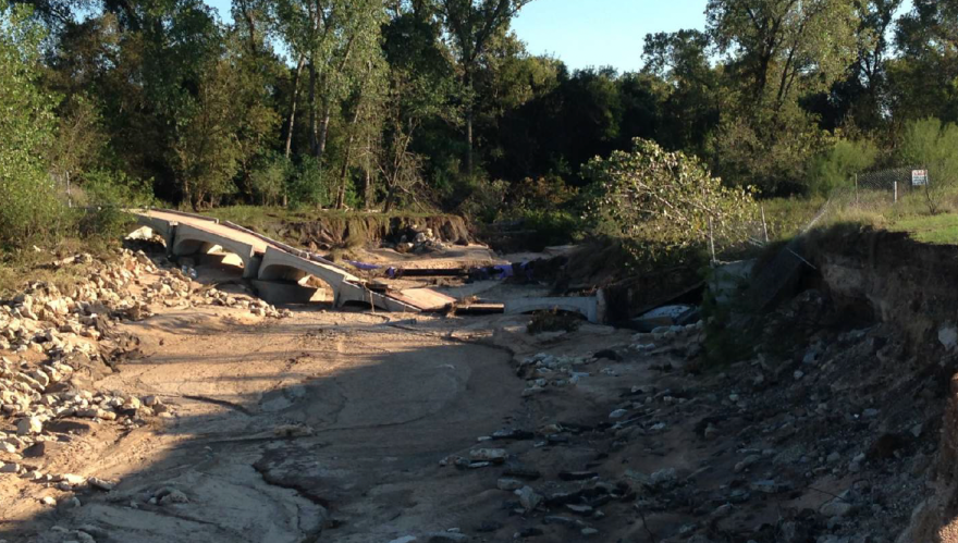
For years, the city has advised people to take a detour as long as 4 miles down Pleasant Valley Road, Riverside Drive and up Grove Boulevard to reach the other side of the park.
Some people instead just walk over a broken chain-link fence and crawl down one side of the gorge and up the other.
“It’s kind of dangerous at times, especially if it’s wet. You probably shouldn’t be here if it’s wet. I’ve definitely slipped on it before,” said Michael Wagoner, who was carefully navigating a precipitous trail through sharp rocks on his way to the disc golf course Wednesday. “I’d like for it to be replaced, personally.”
On Thursday, Austin City Council approved a project to install a new steel truss pedestrian bridge. The bridge replacement has been delayed for years because of a more expensive challenge: stabilizing the disintegrating channel.

Fast erosion moving through the creek kept widening the channel’s footprint, devouring acres of adjacent land and even toppling tall Cottonwood trees.
“It’s really a man-made system that is now unravelling, and 2015 was really a tipping point for that system,” said Janna Renfro, a supervising engineer with the Watershed Protection Department. “All the sudden we had very rapid erosion moving through the park up that channel. That erosion was multitudes of times faster than what we would see in normal creeks.”

Geotechnical firms hired by the city to examine the soil bored into the ground and discovered clean sand 40 feet deep “like you would see in a volleyball court,” Renfro said. “We describe this problem as having a firehose in a sandbox.”
The city has attempted temporary repairs, including one to protect a 54-inch-wide wastewater line that runs under the creek. But nothing has stopped the erosion.

Ultimately, city engineers created a small model of the creek in a laboratory to determine if the design they were proposing would hold the channel system in place. The model experiment told them they needed to go bigger.
The $25.2 million project before City Council is the result of that work. Three 150-foot-wide concrete drop structures will knock the energy out of the water as it moves downstream. Large limestone boulders will stabilize the edges of the channel. The creek will remain natural between the structures.
The new bridge will run atop the middle of the three structures. The pedestrian crossing will be elevated above the 100-year flood plain, so it shouldn’t have to close during most heavy rains.
The bridge will be 164 feet long and 14 feet wide, according to engineering drawings included in the city’s solicitation for bids on the project.

If City Council approves the project, construction is scheduled to start in July or August and finish in 2024.
This story was produced as part of the Austin Monitor’s reporting partnership with KUT.
The Austin Monitor’s work is made possible by donations from the community. Though our reporting covers donors from time to time, we are careful to keep business and editorial efforts separate while maintaining transparency. A complete list of donors is available here, and our code of ethics is explained here.