Key Players & Topics In This Article
Transportation Department: This city department is responsible for municipal transportation planning including roadways and bikeways.
Austin is in the process of adopting several plans that will guide the future of development and transportation in the region. Yesterday, the city revealed a new guide for the future of street design.
It takes into account some key considerations to try to make Austin streets more uniform and consistent, including the community surrounding a street, the number of lanes and planning for different modes of transportation, like bikes and public transit. Annick Beaudet with the Austin Transportation Department said the guide would update Austin’s existing transportation plan, which has been in place for more than 20 years.
“We have safety issues, we have traffic congestion, and that calls for more travel choices to help ameliorate those issues that we’re having with transportation,” Beaudet said.
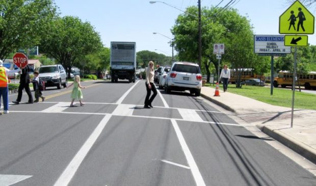
City staff said Austin’s current transportation plan was designed primarily with cars in mind and that it doesn’t reflect changing transportation needs. The new guide divides each street into three sections – pedestrian zones, bicycle zones, and motor vehicle and transit zones – and recommends dimensions for each of those features. It also categorizes streets by their context, like urban, suburban or industrial.
Liane Miller, a project coordinator with the transportation department, said features like sidewalks and bike lanes may be ramped up or scaled down depending on the street function.
“Many of our streets, like Lamar for example, traverse many different places and should be context-sensitive and reflect the context of those places and may look different in different parts of town,” Miller said.
The guide lays out a series of combinations, called cross sections, illustrating how streets could look in different parts of the city. Miller said the existing transportation guide offers a lot more options, which can be difficult to make sense of.
“And it’s a little bit confusing for designers, engineers, planners to figure out what might be the best cross-section for a given street, so we kind of want to simplify that a little bit,” she said.
Tuesday’s unveiling of the guide was well-attended by city staff and private sector developers. Some raised questions of how a uniform street design would work in a city that’s starkly divided along economic lines. One developer noted that people who work lower-paying jobs in the city center typically have to live further out, and they have little choice but to drive into Austin.
Beaudet said it’s clear there is still a need for people to drive, but the goal is to make Austin a little less auto-centric and better designed for transit. Comments on the guide will be accepted through the end of this year on the Austin Transportation Department’s website.
This story was produced as part of the Austin Monitor’s reporting partnership with KUT. Photo courtesy of the Austin Street Design Guide, embedded below.
The Austin Monitor’s work is made possible by donations from the community. Though our reporting covers donors from time to time, we are careful to keep business and editorial efforts separate while maintaining transparency. A complete list of donors is available here, and our code of ethics is explained here.

And we’re honored you look to us for serious, in-depth news. You know a strong community needs local and dedicated watchdog reporting. We’re here for you and that won’t change. Now will you take the powerful next step and support our nonprofit news organization?
Transportation Department: This city department is responsible for municipal transportation planning including roadways and bikeways.