
Members of the public have weighed in on Mayor Steve Adler’s $720 million transportation bond proposal. While we know generally where the money would go if voters approved the bond, the spending on subcategories is still subject to change, with City Council members having taken the first two of three votes needed to officially place the bond on a November ballot.
A majority of the money – $482 million – would be spent on implementing changes to eight of Austin’s major arterials. (Check out a breakdown of each street below, plus a sample intersection and how it could change.) The remainder of the money would go toward planning, changes to smaller outlying roads, safety, and sidewalk and bike infrastructure not included in the plans of these major streets.
Flip through these plans, and you might notice something surprising for Austin: an emphasis on bike lanes and sidewalks. In 2014, City Council adopted a Complete Streets policy, which focuses on green spaces and multimodal transit.
It’s important to note that while the mayor’s proposed spending on some of these street plans (particularly North Lamar, Burnet, Airport and South Lamar) appears to fund these changes in full, staff has noted that when taking into account project management costs and inflation, the street plans (those portions that are within city limits) would cost closer to $1.5 billion. While some funding has already been set aside for portions of these street plans, the funding is minimal, and most of it would be coming from a 2016 bond.
North Lamar Boulevard
Estimated Cost: $75.8 million
Proposed Spending: $85 million
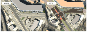
Short-term recommendations include helping out people forgoing car transit by installing pedestrian hybrid beacons and sheltered bus stops. Additional short-term changes can be seen below at the intersection of North Lamar and Rundberg – including wide sidewalks, bike lanes and raised, tree-covered medians between travel lanes. In the long term, staff recommends adjusting signal timing and installing additional turn lanes and sidewalks. Read the full plan here.

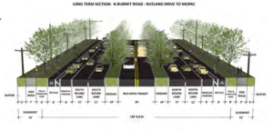
Burnet Road
Estimated Cost: $77 million
Proposed Spending: $80 million
Short-term changes mirror those for North Lamar, with a focus on pedestrian safety (installing pedestrian hybrid beacons) and easing drivers’ turning woes by building more right- and left-turn lanes. In addition to the revised look seen below (medians, bike lanes, etc.), long-term changes also focus on turning lanes, with recommendations to install left-turn lanes at Braker and Kramer lanes. Read the full plan here.
East Riverside Drive
Estimated Cost: $360.8 million
Proposed Spending: $83 million
Many of these recommendations assume that there will be light rail along this corridor – but hopes of light rail were effectively dashed Thursday night, as Caleb Pritchard reports here. Short-term recommendations include closing off driveways to improve safety and widening or building sidewalks to be at least 12 to 15 feet wide. Two long-term recommendations include reducing the number of lanes on Riverside from three to two and building a seven-to-eight-foot protected bicycle lane. Read the full plan here.
Part of this plan is already underway at East Riverside and Lakeshore Boulevard. It’s being funded by money from a 2012 transportation bond.
Airport Boulevard
Estimated Cost: $74.4 million
Proposed Spending: $75 million
Short-term changes include a focus on pedestrian safety by installing pedestrian hybrid beacons at intersections such as Airport and 55th Street and Airport and Zach Scott Street. In addition, staff recommends adding turn lanes at Airport and Manor Road and Airport and Aldrich Street.
Over the long term, recommendations include maintaining the roadway’s four lanes while building out alternatives to car travel: bike lanes and sidewalks. Most of the costs have been targeted for the section of Airport between MLK Boulevard and Levander Loop. Read the full plan here.

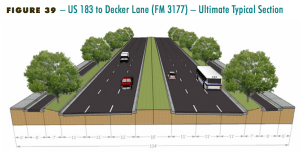
Martin Luther King Jr. Boulevard and FM 969
Estimated Cost: $111.2 million
Proposed Spending: $40 million
The mayor has said that bond money will not be spent on portions of corridor plans that are outside the city of Austin, and most of this particular corridor plan falls outside the city. Many of the recommendations within Austin are short-term changes, most of which focus on bike lanes and sidewalks – including the building of a new sidewalk on one side of FM 696 between U.S. 183 and Decker Lane. Read the full plan here.
South Lamar Boulevard
Estimated Cost: $60.4 million
Proposed Spending: $60 million
Short-term changes include building a two-way bike lane between Riverside Drive and Barton Springs Road, installing new B-cycle stations and building covered bus stops.
More than half of these costs focus on long-term changes to South Lamar between Treadwell Road and the Brodie Oaks Shopping Center, envisioned as a four-lane roadway with raised medians separating car lanes from bike lanes and sidewalks. Read the full plan here.

Guadalupe Street
Estimated Cost: No cost estimate (study not yet complete)
Proposed Spending: $60 million
While this street study is still ongoing, the city has some moves in mind. Staff’s preferred change includes diverting bicyclists from Guadalupe onto Nueces Street between 29th and 24th streets and removing a parking lane from a portion of the Drag, replacing it with northbound and southbound bus-only lanes. Read some preliminary ideas here.

William Cannon Drive and/or Slaughter Lane
Estimated Cost: None
Proposed Spending: Unclear
These streets were added last-minute in June, when representatives of South Austin districts made note of few funds going to streets in their districts. While it’s unclear how much could be funneled into these roads, it would most likely go toward creating a street plan as we have for the above streets.
The remainder of the money
What remains: $238 million
The remainder of the $720 million would fund sidewalks, urban trails, bike lanes and changes to smaller roadways, plus future street plans like the ones above. Here is a (preliminary) breakdown of what that would look like. Much of this represents partial funding of these plans. For example, to build only the highest-priority sidewalks would cost the city roughly $200 million. Fully funding the Bicycle Master Plan would cost about $150 million.
- Regional Mobility Projects (including Loop 360 and Anderson Mill Road, among others): $101 million
- Sidewalk Master Plan: $37.5 million
- Safer Routes to Schools: $27.5 million
- Urban Trails Master Plan: $26 million
- Bicycle Master Plan: $20 million
- Sub-standard Road Construction (includes Falwell Lane, William Cannon Overpass Bridge and Ross Road, among others): $11 million
- Vision Zero Plan: $15 million
Top photo: Intersection of South Lamar Boulevard and Barton Springs Road. Photo by Jorge Sanhueza-Lyon/KUT News. This story was produced as part of the Austin Monitor’s reporting partnership with KUT.
The Monitor’s work is made possible by donations from the community. Though our reporting covers donors from time to time, we are careful to keep business and editorial efforts separate while maintaining transparency. A complete list of donors is available here, and our code of ethics is explained here.