Mobility authority unveils MoPac South options
Thursday, October 22, 2015 by
Tyler Whitson MoPac South is back on the public radar, except now community members have several flavors of the proposed highway expansion to choose from as they submit input over the next month.
Responding to a call from residents and elected officials for more options, the Central Texas Regional Mobility Authority unveiled six possible configurations online Wednesday as part of a “virtual open house” that will be available through Nov. 20. This launch precedes an in-person open house that will take place at the Palmer Events Center on Nov. 10.
Members of the public can submit comments on the proposals online and will also be able to do so at the upcoming open house.
While the project’s boundaries run along the MoPac Expressway between Cesar Chavez Street and Slaughter Lane, the configurations differ primarily in how many express lanes – managed toll lanes – the mobility authority would construct and whether or how it would build “direct connections” from those express lanes to downtown Austin.
A proposal similar to the one that sparked public outcry earlier this year – which Travis County Commissioner Brigid Shea called a “double-decking” of MoPac – remains on the table, although with changes such as the removal of access to Austin High School.
That configuration includes an elevated platform over Lady Bird Lake and Zilker Park as well as elevated, one-lane north- and southbound ramps near Cesar Chavez.
The mobility authority estimates that this configuration would cost $350 million and require 1.02 acres of additional right-of-way. It projects that drivers in the year 2035 could expect northbound peak travel times of 32 minutes in the general purpose lanes and nine minutes in the express lanes; southbound peak travel times would be 29 minutes in the general purpose lanes and nine minutes in the express lanes.
Currently, northbound peak period travel times are 23 minutes, while southbound peak period travel times are 16 minutes. Without any construction, the mobility authority projects that those numbers will increase to 52 and 51 minutes, respectively, by 2035.
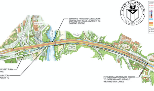
A new configuration that differs substantially from the others is one that city of Austin Transportation Department staff has put forward. That proposal includes two express lanes per direction between Cesar Chavez and U.S. 290 and one per direction between U.S. 290 and Slaughter Lane, along with downtown access.
One of the major differences is that the city proposal replaces the previous proposal’s elevated platform over Lady Bird Lake and Zilker Park with north- and southbound bridges on either side of – and at the same level as – the existing highway.
The mobility authority estimates that the city’s proposal would cost $335 million, require 4.29 acres of additional right-of-way and result in northbound peak travel times of 41 minutes in the general purpose lanes and 11 minutes in the express lanes in the year 2035. Southbound peak travel times would be 37 minutes in the general purpose lanes and 11 minutes in the express lanes.
The other options are one express lane per direction with downtown direct connections, one express lane per direction without downtown direct connections, two express lanes per direction with elevated ramps near Barton Skyway and two express lanes per direction without downtown direct connections.
Estimated prices don’t include “final design, right-of-way acquisition, utility adjustments and other project development costs.”
Rendering of city of Austin proposal courtesy of the city of Austin.
You're a community leader
And we’re honored you look to us for serious, in-depth news. You know a strong community needs local and dedicated watchdog reporting. We’re here for you and that won’t change. Now will you take the powerful next step and support our nonprofit news organization?